Historically, Cave was a key settlement, housing workers for the Levels farm runs and then the railway expansion. Today you can visit the pub, war memorial, and explore local limestone caves and Māori rock art.
The trail begins in the picturesque town of Pleasant Point. Over 19 km of flat terrain, the route leads you to the tiny rural settlement of Cave, with expansive views of the Southern Alps and the iconic Mackenzie Country unfolding as you run, ride, or walk.
Arriving in Cave, you’ll be greeted by sweeping rural scenery, a local store, and the well-known Cave pub, offering refreshments for all ages.
Originally an outstation of the Levels sheep run, Cave grew into a small village with the arrival of the railway and the subdivision of nearby sheep stations. Just over the hill lies St David’s Memorial Church, a striking stone building erected by the Burnett family – pioneers who played a significant role in the early settlement and development of South Canterbury, particularly around Cave and Mount Cook Station.
Although the name suggests otherwise, there are no caves for the public to explore in Cave. The town was named Cave after several limestone caves in the wider area.

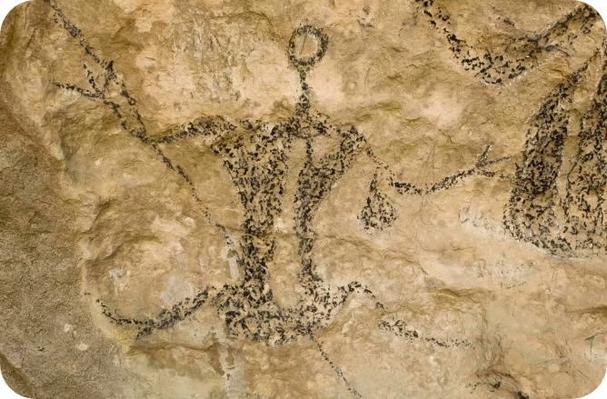
Local Māori rock art
Timaru District is home to the highest number of studied Māori rock art sites in New Zealand with early Māori using the numerous river ways for travel while looking for food as well as materials for medicine, clothing and weapons.
The limestone rock of the district easily erodes creating caves and overhangs which provided shelter for early travellers. While in these shelters, the drawings were created to tell stories and provide warnings to other travellers coming through the area.
Discover the haunting beauty of historic Ngāi Tahu rock art in the Opihi Valley near Pleasant Point. Guided tours run from November to April.